Evolution of China’s Official Position
In 2009, China introduced the map with U-shaped line to international community officially for the first time. Before that, although China circulated internally maps with the line, the country did not mention it as a claim in communication with other countries. Its claims in the South China Sea – as stated in official statements, the white book published during the 1980s and the official website of China’s ministry of foreign affairs during 2000s – were just limited to sovereignty over islands there, particularly Paracels and Spratlys. (16) During 1990s, China also proposed for joint development only for Spratly islands. In 1993 China’s Premier Li Peng asserted that:
“On the issue of Spratly Islands whose sovereignty belong to China, our country puts forward the proposal of ‘shelving disputes in favor of joint development,”(17) (emphasis added). According to Hasjim Djalal, in 1996 Chinese foreign minister Qian Qichen assured his Indonesian counterpart Ali Alatas that there was no problem between two countries when the later requested explanation about the U-shaped line. (18) China also did not object to the agreement on delimitation of continental shelf between Vietnam and Indonesia signed on 26 June 2003. Part of delimitated area is overlapping with a portion of waters within U-shaped line. (19)
In May 2009, while protesting the joint submissions of Vietnam and Malaysia on the outer limit of continental shelves in the South China Sea, China circulated internationally a map with U-shaped line for the first time in a Note Verbal to United Nations Commission on the Limits of Continental Shelf (CLCS). China asserted its “indisputable sovereignty over the islands in the South China Sea and the adjacent waters, and enjoys sovereign rights and jurisdiction over the relevant waters as well as the seabed and subsoil thereof.” (20)
On April 14, 2011, in response to Philippine note verbal to CLCS to protest against China’s U-shaped line, China sent a Note accusing the Philippines of “invading” and “occupying” some islands and reefs in “China’s Nansha Islands”. China’s note also declared that “under the relevant provisions of the 1982 UNCLOS, as well as the Law of the People’s Republic of China on Territorial Sea and Contiguous Zone (1992) and the Law on the Exclusive Economic Zone and the Continental Shelf of the PROC (1998), China’s Nansha Islands is fully entitled to Territorial Sea, EEZ and Continental Shelf” (21) (emphasis added).
Some commentators have highlighted this development as a China’s attempt to clarify its claim and justify the claim under the UNCLOS”. (22) However, after the first cable-cutting incident with Vietnam on 26 May 2011 when Chinese maritime surveillance vessels use special equipment to cut the seismic cable of a Petro Vietnam oil exploration ship, it is possible that China has realized that attempting to clarify its claim in line with the UNCLOS would not serve its ambitious interest. It is hard for China to justify its actions because the area where the first cable-cutting incident occurred is located not only within 200 nautical miles Vietnamese exclusive economic zone but also on the western side of any equidistant lines between the Vietnamese mainland and the Paracel and Spratly Islands. Consequently, the area of incident was not on maritime zone of features of Paracel or Spratly even in case these features are given maximal effect in generating exclusive economic zones (see map 2). China therefore simply turned to the argument of “historic right” in its assertion of the U-shaped claim, which is not in conformity with the UNCLOS. In his remarks at the ARF 18 in July 2011 in Indonesia, China’s Foreign Minister Yang Jiechi for the first time officially stated that “the dotted line was formally announced by the Chinese government in 1948” and that “China’s sovereignty, rights and claims in the South China Sea were established and developed in the long course of history” (23) (emphasis added). On September 15, 2011, in response to questions from the media of whether China’s claim in the South China Sea violates the UNCLOS, Chinese MOFA Spokesperson also said that “China’s sovereignty, rights and relevant claims over the South China Sea have been formed in the long course of history” and “the UNCLOS …does not restrain or deny a country’s right which is formed in history and abidingly upheld.” (24) (emphasis added)
It seems that People’s Republic of China already clarified its U-shaped claim. China now officially using the combination of the concept of sovereign rights in the exclusive economic zone and continental shelf provided for in the UNCLOS 1982 and the concept of “historic rights” for claiming all living and nonliving resources within U-shaped line.
Asserting Activities on the Sea
Parallel with clarifying the U-shaped claim, since 2009, China has significantly increased its presence within the line with a comprehensive approach, expanding not only military but also paramilitary and civilian activities in the area, to achieve de facto control of the area in the South China Sea set by the line.
Relating to the military activities, China is accelerating military build-up, especially naval modernization with the construction of a naval base in Sanya that could serve as a gateway to the South China Sea. To send messages of deterrence to other claimants in the South China Sea, the Chinese navy has also increased the frequency and level of coordination in conducting naval exercises in the South China Sea. The most significant event happened in July 2010 when the PLA navy for the first time mobilized at least a dozen modern warships from three fleets (the North Fleet, the East Fleet, and the South Fleet) to conduct a large-scale joint naval exercise in the South China Sea. (25) Most recently, on June 28, 2012, China’s Ministry of Defense announced that China commenced combat-ready patrols in disputed waters in the South China Sea. (26)
Concerning paramilitary activities, China has deployed systematically patrol vessels and boats from various Chinese maritime law enforcement agencies to the South China Sea. China has at least five maritime law enforcement agencies: the China Coast Guard is the maritime branch of the Public Security Border Troops, a paramilitary police force under the leadership of the Ministry of Public Security; The China Maritime Safety Administration, part of the Ministry of Transport, is for coordinating maritime search and rescue; The China Marine Surveillance (CMS), a paramilitary maritime law enforcement agency under the auspices of the State Oceanic Administration; The China
Fisheries Law Enforcement Command (FLEC) (an organ of the Fisheries Management Bureau under the Ministry of Agriculture) are responsible for the enforcement of laws concerning fishing and marine resources; and the General Administration of Customs operates a maritime anti-smuggling force. Some scholars observed that every agency has their own patrol vessels and operates independently and uncoordinatedly with each other. (27)
During the period of its unilaterally declared fishing ban between May and August (imposed annually since 1999), Chinese maritime security forces have repeatedly detained Vietnamese fishermen, confiscated fishing boats and charged fines of US $8,000 to $10,000 for their release. In early April 2010, Beijing even announced the dispatch of two large fishery patrol vessels to the Spratly Islands to protect Chinese fishing vessels, which were increasing in number and going further to the south. It was the first time China had done so outside the period of its unilateral fishing ban. (28) On June 23, 2010, the Chinese fishery administration vessel Yuzheng 311 pointed a large caliber machine gun to an Indonesian ship and threatened to attack the ship when a Chinese fishing boat was seized by Indonesian forces in the area within Indonesia’s exclusive economic zones in the Natuna Islands. (29)
With regard to the issue of energy development in the South China Sea, since summer 2007, China has threatened a number of foreign oil and gas companies to stop joint offshore exploration operations with their Vietnamese partners or face unestimated consequences with regards their business with China. (30) While protesting against energy development activities undertaken by other countries in areas within the U-shaped claim, China has on the other hand advocated for joint energy resources development within the U-shaped line in the South China Sea. However, the areas that China proposed were not accepted by other claimant as they are falling within their exclusive economic zones as provided for by UNCLOS, but in distance of five to seven hundreds nautical miles
from Hainan Island – the southernmost Chinese undisputed territory.
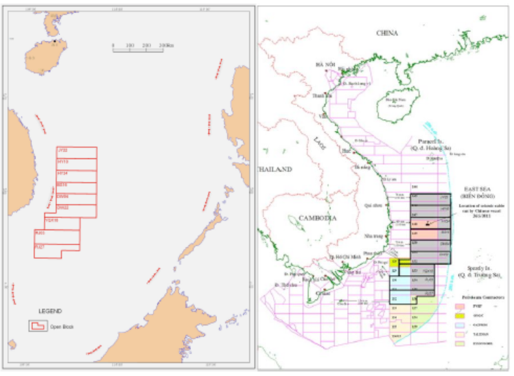
On other hand, since 2007 China have circulated a map of divided petroleum blocks within the U-shaped line in the South China Sea open for bids among Chinese national companies. (see map 3)
In June 2012, China National Offshore Oil Corp (CNOOC), a state oil giant, announced its first major international tender of oil and gas in 9 blocks totally falling within 200 nautical miles from Vietnamese coastline, indicating the readiness of China to unilaterally exploit energy resources in all areas within U-shaped line. (31)
Most recently, in a move to demonstrate its administrative management within the U-shaped line, on June 21, 2012, Chinese State Council approved the establishment of the prefecture-level city of Sansha to administer the Paracels, Macclesfield Bank, and Spratly Islands and “their surrounding waters” in the South China Sea. (33)
(To be continued)
Source: southchinaseastudies.org


Discussion
Trackbacks/Pingbacks
Pingback: China’s U-shaped Line: Possible Interpretations, Asserting Activities and Reactions from Outside (Part 3) | South China Sea - May 18, 2013