Part 8: Towards well-grounded arguments
Based on the ancient records and maps of Vietnam, some comments can be made as follows:
1. Right from the era of the Nguyễn Lords, the Vietnamese had got rather thorough understanding of the existence of these islands. Vietnamese descriptions of the islands are more detailed and precise than those of the Chinese side.
2. The signs of the discovery and the affirmation of ownership of the islands had been recorded with decisions of the Nguyễn Lords on sending teams of boats there for a number of months each year.

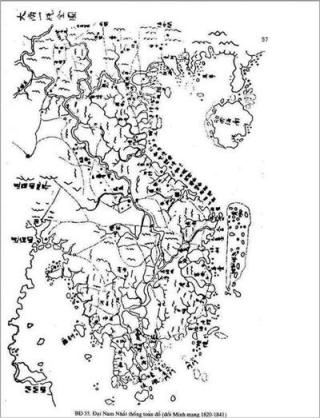
Maps of Vietnam during the Nguyễn Dynasty drawn around 1838 describe “Hoàng Sa” and “Vạn lý Trường Sa” belonging to Vietnam’s territory, off the coastal islands of Central Vietnam – Photo: Biengioilanhtho.gov.vn
The problem here is where the activities in the capacity of the state exactly took place? For the Vietnamese, these activities are aimed at affirming the ownership title of the Hoàng Sa (Paracels) and Trường Sa (Spratlys) archipelagoes. On the contrary, the Chinese side holds that the Hoàng Sa archipelago referred to by Vietnam is not the Xisha Islands of China, it can only be the islands and sand banks along the coast in Central Vietnam”[1] with two arguments as follows:
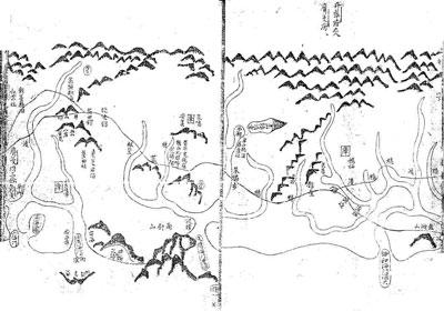
First, Hồng Đức maps noted that it took one and half day to reach Hoàng Sa from the Vietnamese coast, however, with the then navigation engineering, “sailboats cannot reach there in half or one day and a half.”
Second, Phủ biên tạp lục recorded that Hoàng Sa is composed of more than 130 mountains, whilst the Xisha Islands are “low and flat” and “with only 35 islands, submerged cays and sand banks”; and also according to Phủ biên tạp lục “Bãi Cát Vàng is estimated 30 dặm long, whilst the length of Vĩnh Hưng Island, the largest one within the Xisha Islands of China, is less than two kms with the acreage of less than 1.85 km2 [2].

Hồng Đức maps (1774) with clear topography of Đằng Trong (Southern Vietnam) in late 18th century, from Đồng Hới to the border with Cao Miên (Cambodia), drawn by Duke Bùi Thế Đạt for submission to the Trịnh Lord in 1774 to serve the Southward campaign in 1775. On the map, Bãi Cát Vàng was drawn off the sea of Quảng Ngãi prefecture – Documentary photo.
Vietnam counter-argues that all the ancient maps differentiate the islands of Hoàng Sa and Trường Sa with the coastal islands along Vietnam. China deliberately ignores the reference to the official historical books and documents of Vietnam, such as Đại Nam nhất thống chí (1865 – 1882), Lịch triều hiến chương loại chí (1821), Việt cương giám khảo lược, all of which describe the distance of 3-4 days of sea-faring from the shore to the islands.
Đại Nam nhất thống chí (1882) reads in part:
“Hoàng Sa Islands lies in the east of Ré Island, under Bình Sơn district. From Sa Kỳ coast, it can take three or four days to sail to the islands under favorable wind. There are more than 130 small islands, separated by waters, which can take a few hours or a few days to go from one to another. Within the islands is the golden sand-bank, spanning tens of thousands of dặm and thus called Vạn Lý Trường Sa.”
Maps of the East Sea published by the London Publishing House in 1791 – A new chart of the China Sea with its several entrances, printed for Robert Sayer, London in 1791. The difference in this map is that the Paracels archipelago is shown in a pennant with note “according to the Draft of Cochinchina Pilot 1764”. This document shows that while compiling documents for maritime navigation, Western navigators referred to the understanding of the Annam authorities and recognized that the archipelago belonged to Annam.
At first, when Hoàng Sa was discovered by the Vietnamese, it was only known as an area with numerous isles, rocks and submerged cays, stretching thousands of dặm without differentiation as two separate archipelagoes. They were combined as one under the name Đại Trường Sa – Hoàng Sa – Vạn Lý Trường Sa. Later, under the Nguyễn Dynasty, to be more precise, each archipelago was given its own name: Paracels retained as Hoàng Sa, and Spratleys meant Vạn Lý Trường Sa, and later, Trường Sa, for short [3].
In the map of Đại Nam nhất thống toàn đồ (1838), each archipelago had its own name: Vạn Lý Trường Sa and Hoàng Sa. However, they were still considered as one; on the map, both archipelagoes were circled in a dotted ring. In term of administrative management, Hoàng Sa detachments were also in the charge of Bắc Hải detachments, with duties of exploiting the islands south of and within Côn Đảo area. The geographical name and operation area of the Bắc Hải detachments conform to Trường Sa area. Today, the combined number of islands, rocks and sand banks of both archipelagoes amounts to about 130, depending on the way of calculation.
By Dr. Nguyễn Hồng Thao
[1] The White Paper of the Ministry of Foreign Affairs of the People’s Republic of China in 1980, page 11. Han Zhen Hua, “The Paracels mentioned in the Western books are not the Xisha archipelago of our country,” Guangming Daily, Beijing, April 5, 1980.
[2] Han Zhenhua, the cited book.
[3] Lãng Hồ, “Hoàng Sa and Trường Sa are Vietnam’s territory,” Tập đặc san Sử Địa (Special Issue of History and Geography) No. 29, Saigon, 1975, page 73.
Discussion
No comments yet.